Presentation Information

Confidentiality rule:
Numbers based on 0-4 events are classified as a separate static class when a sub-county level geography (Census Tract or County Commission District) is chosen. This is done to assure confidentiality.
Not Reportable
At the County level or higher rates (and percents) based on 1-4 events are not reported due to statistical reliability reasons. At sub-county level (Census Tract or County Commission District), rates and percents based on 0-4 are not reported. This assures confidentiality.
Trendable Maps
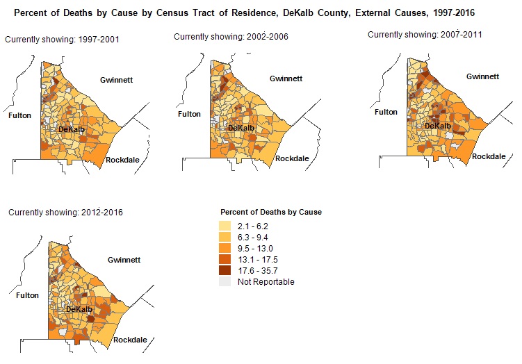
Trendable maps are a series of choropleth maps showing change in spatial distribution of data in a selected area over selected period of time. Trendable maps share the same data class breaks which allows easy comparison between each map in the series.
Trendable Maps

Mapping Units:

Visible Layers:

Cities/Towns
A mix of both incorporated places (legal entities) and census designated places or CDPs (statistical entities). An incorporated place is established to provide governmental functions for a concentration of people. Places always nest within a state, but may extend across county and county subdivision boundaries. An incorporated place usually is a city, town, village, or borough, but can have other legal descriptions. CDPs are delineated to provide data for settled concentrations of population that are identifiable by name, but are not legally incorporated under the laws of the state in which they are located. Click on city/town name to highlight the boundary. Reference Source: U.S. Census, 2020.
GA House Districts
Electoral districts from which State Representatives are elected. The Georgia Constitution requires not less than 180 Representatives apportioned by population from representative districts. Layer Source: https://www.legis.ga.gov/, Adopted 2023 – Effective for 2024 Elections.
GA Senate Districts
Electoral districts from which State Senators are elected. The Georgia Constitution limits the number to not more than 56 single member districts. Senate districts are apportioned based on population. Layer Source: https://www.legis.ga.gov/, Adopted 2023 – Effective for 2024 Elections.
Hospitals
Hospitals are inpatient medical facilities in Georgia. Click on the symbol to get the name. Updated 6.23.2025.
Interstates
Interstates are the freeways that are part of the Interstate Highway System in Georgia. The Interstate Highway System connects major cities within the United States. Click on the line to get the Interstate number. Layer Source: Esri, March 1, 2012.
Major Roads
Major roads are a combination of both federal and state highways connecting cities and towns. Click on the line to get the route number. Layer Source: Esri, March 1, 2012.
Perinatal Regions
The Perinatal Regions were established by the Department of Public Health in cooperation with the six teaching hospitals located in Atlanta, Albany, Augusta, Columbus, Macon and Savannah. The Regions reflect the hospital referral patterns for high risk pregnant women and newborns Each of the six hospitals has a Regional Perinatal Center which has contracts with the state and receives funding to care for high risk pregnant women and infants as well as to train staff from other hospitals in perinatal care especially for high risk patients. Reference Source: Georgia Department of Public Health, March 2005.
ZIP Code
Established by the U.S. Postal Service for distribution of mail. Zip codes do not generally respect political boundaries or census areas such as tracts. Zip codes usually do not have clearly identifiable boundaries, often serve a continually changing area, are changed periodically to meet postal requirements, and do not cover all land area in the U.S. Layer Source: Esri, June 1, 2020.

Base Layers:

Base layers are background information to provide contextual references for local-level maps. They are especially suited for tract-level maps and give real-world reference to maps you create in OASIS. There are six toggle-able (on/off) base layers:
Aerial Photograph
World Imagery provides one meter or better satellite and aerial imagery (ESRI).
Simple Street
Light Gray Canvas provides a neutral background with minimal colors, labels, and features allowing the choropleth maps to come to the foreground (ESRI).
Socioeconomic (SES) Vulnerability
Socioeconomic (SES) Vulnerability refers to the socioeconomic status domain/subset of the CDC’s Social Vulnerability Index (SVI) 2020. Socioeconomic vulnerability ranks census tracts within Georgia on 5 factors: below 150% poverty, unemployed, housing cost burden, no high school diploma, and no health insurance. Percentile ranking values range from 0 to 1, with higher values indicating greater vulnerability/lower socioeconomic status. Quintiles of the percentile rankings were used to create class breaks (Very Low, Low, Average, High and Very High SES Vulnerability). Keep in mind that “Very Low” SES Vulnerability equates to a High SES status. For more information see https://www.atsdr.cdc.gov/placeandhealth/svi/index.html. For data dictionary click here.
Street and Place Names
National Geographic World Map, developed by National Geographic and Esri, is designed to be used as a general reference map for informational and educational purposes (ESRI).
Street Map
World Street Map includes highways, major roads, minor roads, one-way arrow indicators, railways, water features, cities, parks, landmarks, building footprints, and administrative boundaries, overlaid on shaded relief for added context (ESRI).
Street Topographical
World Topo Map includes administrative boundaries, cities, water features, physiographic features, parks, landmarks, highways, roads, railways, and airports overlaid on land cover and shaded relief imagery for added context (ESRI).

Data Classification Methods:

Quantiles: splits the data into equal-sized groups, for example dividing all 159 counties into 5 groups from smallest number to largest. Roughly 32 counties will be in each group.
Natural Breaks (Jenks): looks for clusters in the data and groups similar values together, so each group has numbers that are more alike. For example, if mapping counts by county, Fulton may stand out by itself and be the only county in its group.
Which to use? That depends on what questions you’re trying to answer, and the distribution of the underlying data. Quantiles usually produces more compelling maps when using the Trendable Maps feature on OASIS. Jenks is useful to highlight natural patterns in the data and outliers. In sum:
Quantiles: Showing Overall Spatial Patterns Across Areas
Natural Breaks (Jenks): Highlighting Areas With Distinctly High or Low Values

Definitions:

Data Classes
Also referred to as "class breaks" or groupings of data.
Ethnicity
Hispanic or Latino includes persons of Mexican, Puerto Rican, Cuban, South or Central American, or other Spanish culture or origin, regardless of race. Non-Hispanic + Hispanic may not equal the total number of events due to persons of unknown ethnicity.
General Pregnancy Rate
The number of pregnancies that occur to women of all ages per 1,000 females ages 15-44 years of age. Formula = [Number of pregnancies / Female population 15-44 years of age] * 1,000. Rates that use Census Population Estimates in the denominator are unable to be calculated when the selected population is Unknown.
Percent of First Pregnancy
The number of first pregnancies per 100 pregnancies. Formula = [Number of 1st pregnancies / Number of pregnancies] * 100
Percent of Repeat Pregnancy
The number of pregnancies that are not first pregnancies per 100 pregnancies. For example, repeat pregnancy can be presented for females aged 10-19 and age groups between 10-19 (10-17, 10-14, 15-17, 18-19).
Formula = [Number of repeat pregnancies in age group / pregnancies in age group] * 100.
Pregnancy
A pregnancy is a human conception that results in a live birth, fetal death or an induced termination of pregnancy. The total number of conceptions that result in one or more live births, fetal deaths (of all gestational ages), or induced terminations of pregnancy are used to sum the total number of pregnancies. Therefore, Ectopic and Molar pregnancies are not included, and conceptions that result in multiple births (twins, triplets, etc.) are counted as one pregnancy.
Pregnancy Rate
The number of pregnancies occurring to females in a specified age group per 1,000 females in the specified age group. Formula = [Number of pregnancies in age group / Female population in age group] * 1000. Rates that use Census Population Estimates in the denominator are unable to be calculated when the selected population is Unknown.
Race
Per the Federal Office of Management and Budget, Directive 15 (1997),

Navigation Tools

Zoom Use scroll wheel; or Shift+click and drag mouse to draw zoom area; or use + - buttons.
Full Extent Full Extent: Select this button to see the entire map.
Pan Click and hold mouse.
Print Map: Click on this button to get a printable copy of the map in PNG format as it appears at the moment. Disable any pop-up blockers. Right click on the preview and you can choose to save, copy or print the preview. The preview can also be dragged and dropped to a folder or desktop.

V1.14 (7/29/2025)