Census populations include military, students, and institutionalized persons if in their usual and customary residence. Documentation and file layouts are available from the U.S. Bureau of the Census web site.
Population data for years 1994-1999 are the National Center for Health Statistics Bridged-race estimates. These estimates replaced the Census' postcensal estimates on 1.12.04.
The 2001-2009 Census postcensal estimates were replaced by the October 2012 release of the Census' intercensal estimates in November 2012. This Census release also contained new estimates of the 2000 and 2010 population and they too were updated in November 2012.
2010-2020 Intercensal estimates (and adjustments to 2010 and 2020 Census counts) were released Sept 30, 2025. Upon review, 2010-2020 had internal consistency but were quite different from the already-published 2021-2024 Postcensal estimates. Due to anticipated fixes to years 2021-2024 scheduled with the release of 2025 postcensal estimates, the decision was made to update the entire span of population counts from 2010-2024, and publish 2025 Postcensal estimates at one time. On 6/26/2026, 2010-2019 population counts were updated with Intercensal Estimates, and 2020-2024 were replaced with updates included in the release of the 2025 Postcensal estimate.
Single year of age estimates in non-censal years are created by Office of Health Indicators for Planning (OHIP), Department of Public Health by applying Decennial single year of age proportions to non-decennial years.
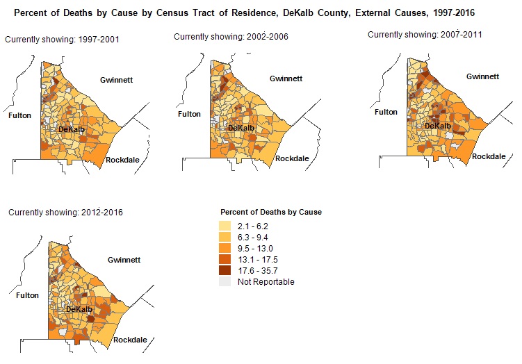
| Zoom | Use scroll wheel; or Shift+click and drag mouse to draw zoom area; or use + - buttons. |

|
Full Extent: Select this button to see the entire map. |
| Pan | Click and hold mouse. |
| Print Map: Click on this button to get a printable copy of the map in PNG format as it appears at the moment. Disable any pop-up blockers. Right click on the preview and you can choose to save, copy or print the preview. The preview can also be dragged and dropped to a folder or desktop. |
V1.16 (6/26/2026)